

Norris Lake rises
Heavy rains bring flooding concerns to area
-
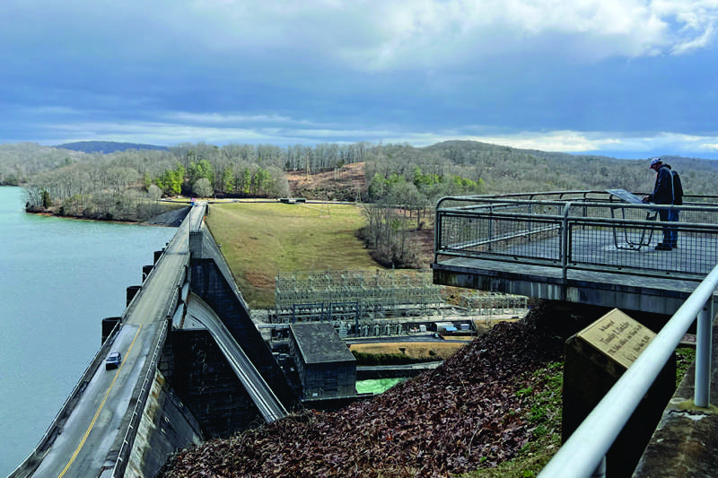
Visitors check out the dam, spillway and Norris Lake from the overlook above the dam on Sunday morning (Feb. 16). TVA said the lake was three feet above its normal summer level on Monday after several days of heavy rainfall. - Emma Jayne Williams
-
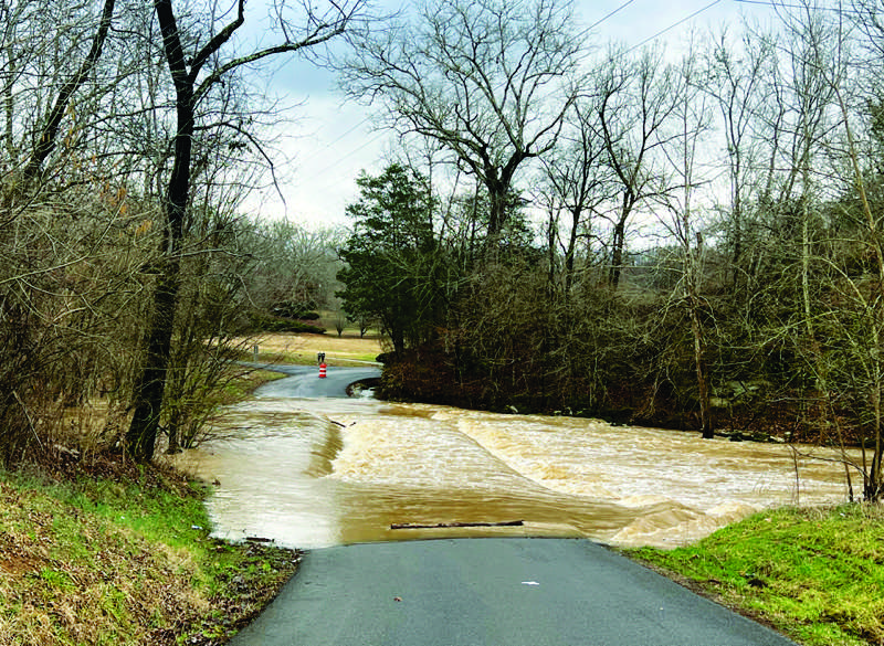
Hinds Creek runs over the low-water bridge on Irwin Mill Road off Sinking Springs Road in Clinton on Sunday morning (Feb. 16). The road had been closed to traffic since Feb. 12 because of the heavy rains last week. - Emma Jayne Williams
-
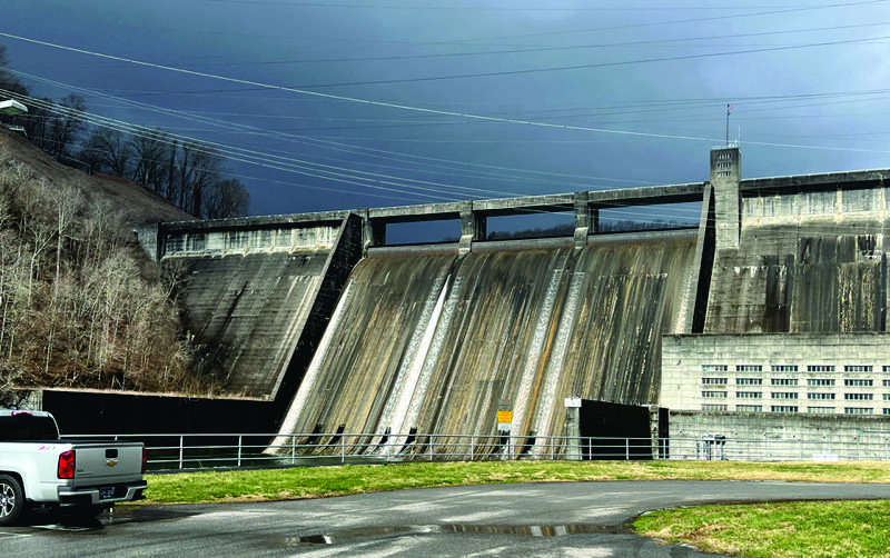
With ominous clouds lurking overhead, water flows through spillway outlets in Norris Dam on Sunday morning (Feb. 16) as water is released following nearly a week of heavy rains. - Emma Jayne Williams
-
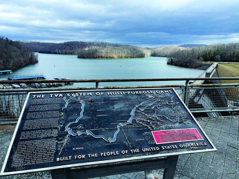
This is how Norris Lake looked Sunday morning (Feb. 16) after several days of heavy rain, which raised the lake to three feet above its normal summer level, TVA said Monday. - Emma Jayne Williams
With more than 4.5 inches of rain falling in just under four days in the Clinton area, Norris Lake was sitting at three feet above its normal summer level on Monday, but continued to hold water back safely to minimize any flooding downstream, the Tennessee Valley Authority said Monday.
Residents in many areas of Anderson County had to deal with standing water in their yards, but there were no immediate reports of any serious flooding of homes or businesses.
Still to come: Snow is in the forecast for today and Thursday (Feb. 19-20). The National Weather Service on Monday issued a “winter weather advisory” beginning at 2 a.m. today (Wednesday).
As for the heavy rains, on Monday TVA warned in a social media post to “expect very high flows on the Clinch River below the dam, including at Clinton and Oak Ridge,” as the high volume of water created by the past week’s storms moves through the area.
“More than 16 feet of water is being stored in Norris Lake after heavy rainfall over the past week, increasing the water level in the reservoir to 1,023 feet, three feet above the normal summer pool,” TVA posted on its Facebook page Monday afternoon.
“Low-level sluice gates are now open, and both generating units are at full capacity at Norris Dam to recover flood storage,” the post added.
In nearby Norris, Water Superintendent Tony Wilkerson said Monday afternoon that the city had recorded “a total of 4.5 inches of rain at the wastewater treatment plant over the last five days,” which forced the city to begin diverting stormwater/wastewater coming into the plant directly into nearby Buffalo Creek at 11:15 a.m. on Saturday.
To prevent untreated sewage from flowing into the creek from the plant near the Norris Freeway (U.S. 441)-Andersonville Highway junction, the city added chlorine and sulphur dioxide as disinfectants to prevent the overflow from polluting the creek water, Wilkerson said.
Some rural routes, including Irwin Mill Road over Hinds Creek off Sinking Springs Road in Clinton, were closed by high water as early as Wednesday, and remained impassible on Monday.
Anderson County schools were closed to students on Friday because of high water on some rural roads, but also because of flu, officials said.
Coincidentally, Feb. 16-22 is “Severe Weather Awareness Week,” according to social media posts by the Anderson County Emergency Management Agency.
On Monday, the agency posted about flooding and flash flooding, saying:
“Did you know that just six inches of moving water can knock you off your feet, and 12 inches can carry away a car? Flooding is one of the most dangerous weather hazards we face — are you prepared?
“Know the Risks — Floods can happen anywhere, especially in low-lying areas and near rivers or creeks. Stay informed and be aware of flood watches and warnings issued by the National Weather Service.
“Turn Around, Don’t Drown! — Never attempt to walk or drive through floodwaters. You never know how deep or fast-moving the water is.”
For the most part, however, Clinton and the immediate area seemed to escape the brunt of a severe storm that moved through Tennessee then up along the Cumberland Mountain range early Sunday, where it caused at least 12 deaths in Kentucky.
Just a few miles north of the Tennessee line along Interstate 75, Corbin, Kentucky, experienced severe flooding of its downtown city streets in the aftermath of the Sunday morning storm, according to multiple reports.
Although flooding was less a problem than expected even in northern Anderson County, high winds did bring tree limbs and even some whole trees crashing down, blocking highways, damaging structures and causing power outages.
In Rocky Top on Sunday morning, a tree fell onto a house on Vivian Avenue, knocking down power lines and rupturing gas lines. The incident caused a widespread power outage in the city and prompted emergency services to evacuate the area around the damaged gas lines.
The Rocky Top Police Department posted an all-clear message on social media at 9:46 a.m., Sunday telling people they could return to their homes.
In Norris, Wilkerson said the Water Department also had to back-flush filters at the city’s water treatment plant on Lower Clear Creek Road over the weekend to keep silt that was building up in the creek from getting into the water supply.
“We have had to backwash every day from Feb. 14 through today, where our creeks were getting muddy,” he said. “It’s all good, but it takes extra time. We’ve definitely been working overtime Friday, Saturday, Sunday and today.”